The Nile River, stretching over 6,650 kilometers from Uganda to Egypt, is not only the longest river in the world but also a cradle of ancient civilizations.
Along its course, the river offers an array of breathtaking natural features that reflect the rich biodiversity and historical significance of the region. Here are ten remarkable natural features along the Nile, in order from Uganda to Egypt.
1. Lake Victoria, Uganda

Lake Victoria, the largest lake in Africa, is a primary source of the Nile River. Spanning three countries—Uganda, Kenya, and Tanzania—it covers an area of approximately 68,800 square kilometers. The lake is vital for the local economy, supporting fishing, agriculture, and transportation. It is also a hub for biodiversity, hosting over 200 species of fish, including the iconic Nile perch, and a wide variety of bird species, making it a prime destination for eco-tourists and bird watchers.
Beyond its ecological significance, Lake Victoria is a stunning natural wonder with scenic shores and numerous islands. The Ssese Islands, a group of 84 islands in the northwestern part of the lake, are renowned for their beautiful beaches, lush vegetation, and vibrant local culture. These islands offer opportunities for relaxation, water sports, and cultural experiences, making Lake Victoria not only an ecological treasure but also a major tourist attraction in East Africa.
2. Murchison Falls, Uganda

Murchison Falls is a dramatic waterfall located in the Murchison Falls National Park in Uganda. Here, the Nile River narrows from a width of 50 meters to just 7 meters and plunges 43 meters into the "Devil's Cauldron," creating a thunderous roar and a spectacular display of power. This natural wonder is surrounded by a rich tapestry of wildlife, including elephants, giraffes, buffaloes, and numerous bird species, making it a popular destination for safaris and wildlife viewing.
The surrounding Murchison Falls National Park is Uganda's largest and oldest conservation area, covering 3,893 square kilometers. The park offers a variety of activities such as game drives, boat cruises, and hiking. The boat cruise to the base of the falls is particularly popular, offering close-up views of the falls and opportunities to spot hippos, crocodiles, and diverse birdlife along the riverbanks. Murchison Falls stands as a testament to the raw, untamed beauty of the Nile River in Uganda.
3. Sudd Swamps, South Sudan

The Sudd Swamps in South Sudan form one of the world's largest wetlands, covering an area of up to 130,000 square kilometers during the rainy season. This vast, swampy region is a complex maze of channels, lagoons, and papyrus islands, supporting a unique and diverse ecosystem. It is a critical habitat for numerous species, including the endangered Nile lechwe antelope, the shoebill stork, and various fish species that are crucial for local fisheries.
The Sudd Swamps play a vital role in the hydrology of the Nile River, acting as a natural reservoir that regulates the river's flow. The swamps are also of great cultural and economic importance to the local communities, who depend on fishing, agriculture, and pastoralism for their livelihoods. However, the region faces challenges such as seasonal flooding, water management disputes, and the impacts of climate change. Efforts to protect and sustainably manage the Sudd Swamps are crucial for preserving this unique wetland ecosystem.
4. Nile Confluence at Khartoum, Sudan
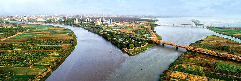
At Khartoum, the capital of Sudan, the Blue Nile and White Nile converge, forming the main Nile River that flows northward to Egypt. This confluence is a significant geographical and cultural landmark, symbolizing the merging of diverse waters and histories. The Blue Nile, originating from Lake Tana in Ethiopia, contributes the majority of the water and silt that sustain the fertile Nile Delta, while the White Nile, originating from Lake Victoria, provides a steadier flow.
The city of Khartoum itself is a vibrant metropolis with a rich history and diverse cultural heritage. The confluence area is marked by the picturesque meeting of the two rivers, visible from the Tuti Island Bridge. Visitors can explore the Sudan National Museum, which houses artifacts from the ancient Nubian and Kushite civilizations, or take a boat trip to enjoy the scenic beauty of the river junction. The confluence at Khartoum is a testament to the dynamic interplay of natural forces and human civilizations along the Nile.
5. Great Bend of the Nile, Sudan

The Great Bend of the Nile is a dramatic, 300-kilometer-long detour in the river's course as it flows through the Sahara Desert in northern Sudan. This unusual bend is caused by the Nubian Swell, a tectonic uplift that forces the river to take a southwestward turn before resuming its northward flow. The Great Bend creates a striking contrast between the lush, green riverbanks and the surrounding arid desert landscape, offering a unique and breathtaking view.
The area around the Great Bend is also rich in archaeological and historical sites. The ancient city of Meroe, the capital of the Kingdom of Kush, lies nearby and is famous for its pyramids and ruins that date back to the 8th century BCE. These archaeological treasures provide insights into the powerful Nubian civilization that once thrived along the Nile. Exploring the Great Bend and its surroundings offers a journey through both natural beauty and ancient history, highlighting the enduring legacy of the Nile River.
6. Lake Nasser, Egypt/Sudan

Lake Nasser, one of the world's largest man-made lakes, was created by the construction of the Aswan High Dam in the 1960s. Stretching over 500 kilometers from Aswan in Egypt to the Sudanese border, the lake covers an area of approximately 5,250 square kilometers. It plays a crucial role in water storage, flood control, and irrigation, supporting agriculture and providing hydroelectric power to the region.
The lake's serene waters and vast expanse offer a unique landscape that contrasts with the surrounding desert. Lake Nasser is also a haven for wildlife, including fish species such as the Nile perch, and attracts numerous migratory birds. The shores of the lake are home to important archaeological sites that were relocated to higher ground to save them from flooding, including the temples of Abu Simbel and Philae. These monuments, with their grand statues and intricate carvings, continue to draw tourists and historians alike, underscoring the cultural significance of the Nile's waters.
7. Aswan Cataracts, Egypt
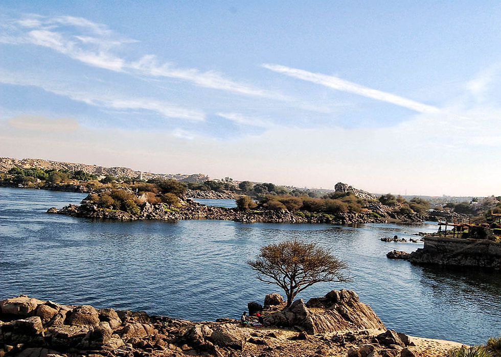
The Aswan Cataracts are a series of six rapids and small waterfalls that occur along a rocky section of the Nile River near the city of Aswan. Historically, these cataracts posed significant navigational challenges and served as natural barriers that protected ancient Egypt from invasions from the south. The first cataract, located just south of Aswan, marks the traditional boundary between Upper and Lower Egypt.
Today, the area around the Aswan Cataracts is a popular tourist destination, known for its stunning natural scenery and rich historical heritage. The Aswan High Dam, constructed nearby, has significantly altered the flow of the Nile, creating Lake Nasser and regulating the river's annual flooding. Visitors to the region can explore the picturesque islands of Philae and Elephantine, visit the Nubian Museum, and take boat trips to experience the beauty and historical significance of the cataracts. The Aswan Cataracts offer a unique blend of natural wonder and cultural history along the Nile.
8. Philae Island, Egypt
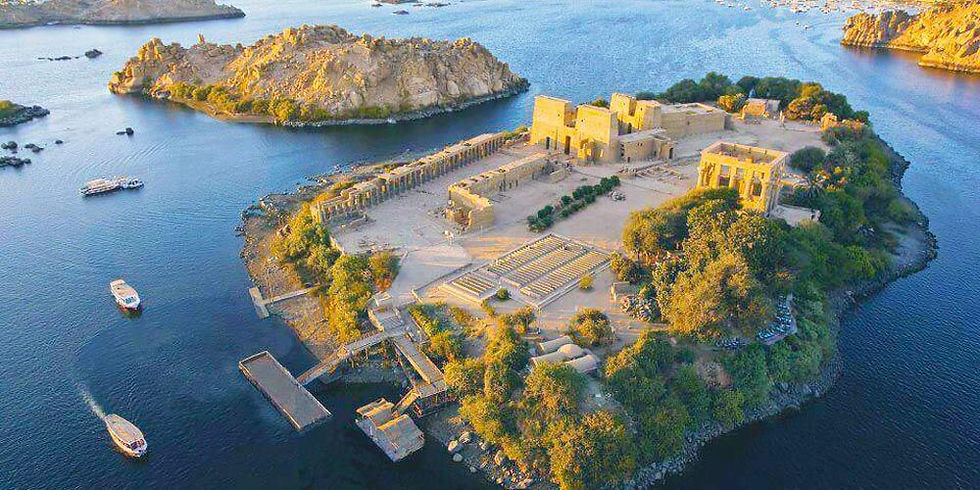
Philae Island, located near Aswan, is renowned for its well-preserved ancient temples, especially the Temple of Isis. The island's lush greenery and tranquil waters create a serene setting that contrasts with the surrounding arid landscape. The Temple of Isis, dedicated to the goddess of motherhood and fertility, features intricate carvings, grand columns, and beautiful reliefs that tell stories of ancient Egyptian mythology.
The temples on Philae Island were relocated to nearby Agilkia Island in the 1960s to save them from the rising waters of Lake Nasser caused by the construction of the Aswan High Dam. This massive UNESCO-led project preserved the island's historical treasures and allowed visitors to continue experiencing the grandeur of ancient Egyptian architecture. Philae Island remains a significant cultural and religious site, attracting tourists who seek to explore its historical significance and enjoy its natural beauty.
9. Nile Delta, Egypt

The Nile Delta is a vast, fertile region where the Nile River fans out before emptying into the Mediterranean Sea. Covering an area of about 22,000 square kilometers, the delta supports a significant portion of Egypt's agriculture, producing crops such as rice, cotton, wheat, and fruits. The rich silt deposits brought by the river's annual flooding have sustained human settlements and agricultural activities for thousands of years.
The Nile Delta is also a crucial habitat for wildlife, including numerous fish species and migratory birds that stop over during their journeys along the East African flyway. The region's waterways, marshes, and lagoons create a diverse and productive ecosystem that supports both human and natural communities. Despite challenges such as land subsidence, pollution, and rising sea levels, the Nile Delta remains a vital and dynamic region that underscores the importance of the Nile River to Egypt's economy and environment.
10. Rasheed (Rosetta) Branch, Egypt

The Rasheed Branch, also known as the Rosetta Branch, is one of the two main distributaries of the Nile Delta. Flowing into the Mediterranean Sea near the town of Rosetta, this branch is historically significant as the discovery site of the Rosetta Stone in 1799. The stone, which provided the key to deciphering Egyptian hieroglyphs, was instrumental in advancing our understanding of ancient Egyptian civilization.